
Munsiyari – A High-Altitude Gem of Kumaon
- Jan 15
- 4 min read
Munsyari is a high-altitude hill station located in the easternmost hill district of Uttarakhand, Pithoragarh. Situated at an elevation of approximately 2,298 metres, it is often referred to as “Little Kashmir” due to its dramatic Himalayan scenery and snow-covered peaks.
Nestled in the Kumaon Himalayas, Munsiyari is a major hub for nature lovers, photographers and high-altitude trekkers, offering breathtaking mountain views and access to some of the region’s most iconic trekking routes.
Key Highlights of Munsiyari
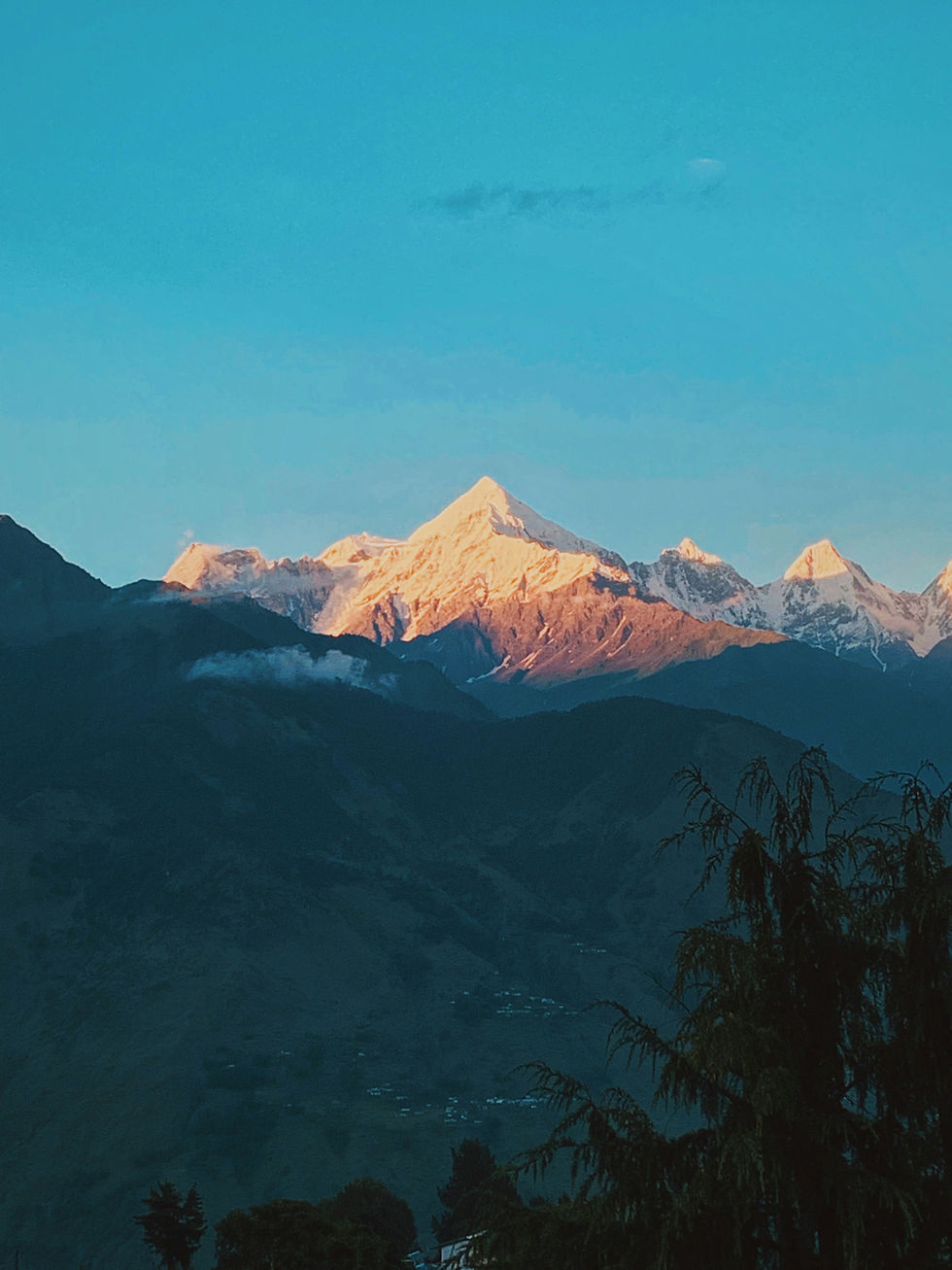
Panchachuli Peaks
Munsiyari offers an iconic and panoramic view of the Panchachuli range, a group of five snow-capped Himalayan peaks that dominate the skyline and are best admired at sunrise and sunset.
Trekking Hub of Kumaon
Munsyari serves as the base camp for several world-renowned treks, including routes to:
Milam Glacier
Ralam Glacier
Namik Glacier
Nanda Devi region
These treks make Munsiyari a preferred destination for serious trekkers exploring the Kumaon Himalayas.
Winter Sports Destination
Munsyari is emerging as a growing centre for skiing and winter sports, especially at Khaliya Top and Betuli Dhar, attracting adventure enthusiasts during the winter season.
Top Places to Visit in Munsiyari
Khaliya Top
Khaliya Top is a popular trekking destination located approximately 6 km from Munsiyari. It offers 360-degree views of the Greater Himalayas and vast alpine meadows.
Birthi Falls
Birthi Falls is a majestic waterfall situated around 35–60 km before reaching Munsiyari, making it an ideal stopover for travellers.
Nanda Devi Temple
A significant spiritual site dedicated to Goddess Nanda (Parvati), the temple is set against a stunning mountain backdrop and holds great cultural importance in the region.
Tribal Heritage Museum
This privately maintained museum showcases the history, culture and lifestyle of the Bhotia community, providing valuable insight into the local tribal heritage.
Thamri Kund
Thamri Kund is a serene natural lake surrounded by dense alpine forests, perfect for peaceful nature walks and quiet exploration.
Best Time to Visit Munsiyari
March to June – Pleasant weather, ideal for sightseeing and trekking
Mid-September to October – Clear skies and crisp mountain views
December to February – Best time to experience snowfall and winter landscapes
How to Reach Munsiyari
By Air
The nearest airport is Pantnagar Airport, located approximately 300 km from Munsiyari.
By Rail
The closest railway stations are:
Kathgodam – 280 km
Tanakpur – 273 km
By Road
From Nainital – 261 km
From Rishikesh – 403 km
From Delhi – 633 km
Ideal Duration of Stay
A stay of 4 to 5 days is recommended to explore Munsiyari comfortably, including nearby treks, viewpoints and cultural attractions.
Accommodation and Food in Munsiyari
Munsiyari offers a range of accommodation options, from good-quality hotels to cosy homestays. Visitors can enjoy authentic Pahari cuisine, along with Indian and limited continental dishes, providing a warm and local dining experience.
FAQs – Munsiyari, Uttarakhand
Q1. What is Munsiyari famous for?
Munsiyari is famous for its panoramic views of the Panchachuli Peaks, high-altitude trekking routes and alpine landscapes. It is also known as a major base for glacier treks such as Milam, Ralam and Namik in the Kumaon Himalayas.
Q2. Which is the best time to visit Munsiyari?
The best time to visit Munsiyari is March to June for pleasant weather and mid-September to October for clear mountain views. December to February is ideal for experiencing snowfall and winter scenery.
Q3. How to visit Munsiyari?
Munsiyari can be reached via Pantnagar Airport (300 km) or Kathgodam and Tanakpur railway stations. From these points, travellers must continue by road via Almora and Bageshwar to reach Munsiyari.
Q4. Is Munsiyari in Kumaon or Garhwal?
Munsiyari is located in the Kumaon region of Uttarakhand, not in Garhwal. It lies in the eastern part of the state within the Pithoragarh district.
Q5. What is the weather like in Munsiyari, Uttarakhand?
Munsiyari has a cool alpine climate. Summers are mild and pleasant, monsoons bring moderate rainfall, and winters are cold with frequent snowfall, especially between December and February.
Q6. Where is Munsiyari located on the Uttarakhand map?
Munsiyari is situated in eastern Uttarakhand, close to the Indo-Tibetan border, within the Pithoragarh district of the Kumaon Himalayas.
Q7. Which are the best places to visit in Munsiyari, Uttarakhand?
The best places to visit in Munsiyari include Khaliya Top, Birthi Falls, Panchachuli Viewpoint, Nanda Devi Temple, Tribal Heritage Museum and Thamri Kund.
Q8. What is Munsiyari tourism known for?
Munsiyari tourism is known for trekking, winter sports, mountain photography and cultural experiences, attracting adventure seekers and nature lovers to this offbeat Himalayan destination.
Q9. What is the average temperature in Munsiyari?
The average temperature in Munsiyari ranges from 10°C to 20°C in summer and −5°C to 8°C in winter, with temperatures often dropping below freezing during peak winter months.
Q10. Munsiyari is in which district?
Munsiyari is located in the Pithoragarh district of Uttarakhand.
Q11. What is the altitude of Munsiyari in feet?
Munsiyari is situated at an altitude of approximately 7,539 feet (2,298 metres) above sea level.
Q12. What are the best things to do in Munsiyari, Uttarakhand?
The best things to do in Munsiyari include trekking to Khaliya Top, glacier trekking, photographing the Panchachuli Peaks, enjoying snowfall in winter, exploring local culture and tasting traditional Pahari cuisine.
If you need more information or would like personalised assistance in planning your journey across Uttarakhand, feel free to contact us at contact@mapchemy.com — we’re here to help you craft the perfect travel experience. And you can also visit our website www.mapchemy.com.


Comments